Introduction
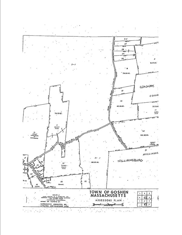
Chester and Gloria Cross (the Crosses) own and reside at the property in Goshen, Massachusetts, shown as lot 10 on the portion of the Town of Goshen Assessors Plan attached as Exhibit A. The Crosses' property is bounded on the west by Brier Hill Road; its southwest corner is at the intersection of Brier Hill Road and Wing Hill Road. This case concerns the section of road, shown as a dotted line on the plan, that runs easterly from the intersection of Brier Hill Road and Wing Hill Road and bounds the Crosses' property to the south. The Crosses have brought this action against the Town of Goshen, the Goshen Board of Selectmen and its members in their official capacity, and the Town of Goshen Highway Superintendent, Todd Dewkett, in his official capacity (the Town). The Crosses seek a declaration that this road to the south of their property, referred to here as the Stub, is a public way.
The Crosses contend that the Hampshire County Commissioners laid out the Stub, rendering it a public way and thereby requiring the Town to repair, maintain, and remove snow for the Stub's entire length. In support of this position, the Crosses highlight the Stub's appearance on ancient town and county maps, and point to early deeds in their chain of title describing their property as being bounded on the south by a "highway." Additionally, the Crosses suggest that the the Town's more recent use and maintenance of the Stub establish that the Stub was laid out as a public way. In the alternative, the Crosses argue that failure to recognize the Stub as a public way would deny residents of the Town access to and enjoyment of a frequented public space, the Tilton Town lot. The Town asserts that no evidence exists to show the Stub was laid out by public authority. The Town further maintains that the existence of the Tilton Town town lot has no bearing on whether the Stub is a public way. Reviewing the record in its entirety and in the light most favorable to the Crosses, the court finds that the Town is entitled to judgment as a matter of law.
Procedural History
The Crosses filed their Complaint against the Town on November 9, 2016. The case management conference was held on December 6, 2016, at which the the Crosses waived any claims for damages and stated that the claims of the complaintCounts I through IV for declaratory judgment, Count V for to quiet title, Count VI for cloud on title, and Count VII for equitable reliefare all directed to a determination that the Stub is a county road named Wing Hill Road that the Town is obligated to maintain and plow. The Town filed its answer on December 15, 2016.
On September 19, 2017, the Crosses filed Plaintiffs' Motion for Summary Judgment and the Statement of Undisputed Material Facts (Pl. Facts). On October 20, 2017, the Town filed Defendants' Opposition to Plaintiffs' Motion for Summary Judgment and Defendants' Cross-Motion for Summary Judgment, Memorandum in Support of Defendants' Opposition to Plaintiffs' Motion for Summary Judgment and Defendants' Cross-Motion for Summary Judgment, Defendants' Response to Plaintiffs' Statement of Material Facts and Statement of Additional Material Facts in Support of Cross-Motion for Summary Judgment (Def. Facts), and Defendants' Additional Exhibits in Support of Cross-Motion for Summary Judgment (Def. Exh.). On November 6, 2017, the Crosses filed their Reply Brief and their Motion to Strike Portions of Defendants' Opposition to Plaintiffs' Motion for Summary Judgment (Motion to Strike). On November 8, 2017, the Town filed Defendants' Opposition to Plaintiffs' Motion to Strike. A hearing on Plaintiff's Motion for Summary Judgment and Defendants' Cross-Motion for Summary Judgment was held on November 9, 2017. At the hearing, the court denied the Motion to Strike without prejudice, and took the Plaintiffs' Motion for Summary Judgment and the Defendants' Cross-Motion for Summary Judgment under advisement. This Memorandum and Order follows.
Summary Judgment Standard
Generally, summary judgment may be entered if the "pleadings, depositions, answers to interrogatories, and responses to requests for admission . . . together with the affidavits . . . show that there is no genuine issue as to any material fact and that the moving party is entitled to judgment as a matter of law." Mass. R. Civ. P. 56(c). In viewing the factual record presented as part of the motion, the court draws "all logically permissible inferences" from the facts in favor of the non-moving party. Willitts v. Roman Catholic Archbishop of Boston, 411 Mass. 202 , 203 (1991). "Summary judgment is appropriate when, 'viewing the evidence in the light most favorable to the nonmoving party, all material facts have been established and the moving party is entitled to a judgment as a matter of law.'" Regis College v. Town of Weston, 462 Mass. 280 , 284 (2012), quoting Augat, Inc. v. Liberty Mut. Ins. Co., 410 Mass. 117 , 120 (1991).
Undisputed Facts
Based on the pleadings, the Statement of Facts, the Defendant's Statement of Facts, and the documents and affidavits submitted in support, the following facts are material and are either undisputed or deemed admitted:
Location of the Crosses' Home
1. The Crosses are married individuals residing in Goshen, Massachusetts. They own the property located northeast of the intersection of Wing Hill Road and Brier Hill Road, shown as lot 10 on the Assessors Plan attached as Exhibit A, by a deed dated January 25, 2006, and recorded in the Hampshire Registry of Deeds (registry) at Book 8599, Page 160. The Stub is shown along the southern bound of the Crosses' property by a dotted line on the Assessors Plan. Def. Exh. 19 at 8 9; Exh. A.
History and Status of Wing Hill Road
2. In 1768, the Hampshire County Commissioners laid out Wing Hill Road. Pl. Facts Exh. 2 at 45.
3. The 1768 Sessions record describes Wing Hill Road as running in a "northerly and northwesterly" direction. Pl. Facts Exh. 2 at 45.
4. The Index of Road Actions for the Town does not describe the Stub. Pl. Facts Exh. 2.
5. In 1991, the Hampshire Council of Governments, in conjunction with the Town, undertook a research project to investigate the history and status of all public ways in the Town . Wing Hill Road was recognized as a county way. Pl. Facts Exh. 1 at 11.
6. At a Special Town Meeting on November 15, 2000, the Town renamed the section of road abutting the Crosses' property to the west. The section of road, previously part of Wing Hill Road, was renamed Brier Hill Road. Def. Exh. 18; Exh.A.
Tilton Town Lot
7. Mr. Spencer Tilton passed away on November 15, 1918. His will left the bulk of his estate to the Town of Goshen and established a trust to administer the real property dedicated to the Town for public use. This real estate included the Tilton Town lot. Pl. Facts Exh. 9.
8. The Tilton Town lot was dedicated to the Town for public use. The lot is shown on the Assessors Plan as Lot 11, immediately to the east of the Crosses' property. Pl. Facts Exh. 12; Exh.A.
9. Currently, the only access to the Tilton Town lot is through the Stub.
Maps
10. The Stub appears on a 1781-1800 map of the Town of Goshen. Pl. Facts Exh. 3.
11. The Stub appears on an 1839 map of the Town of Goshen. Pl. Facts Exh. 4.
12. The Stub appears on an 1854 map of Hampshire County. Pl. Facts Exh. 5.
13. The Stub appears on an 1873 map of Hampshire County. Pl. Facts Exh. 1 at 27.
14. The Stub appears on a 1922 map of Hampshire County. Pl. Facts Exh. 6.
15. The Stub appears on a 1953 map of Hampshire County. Pl. Facts Exh. 7.
16. The Stub does not appear on a 1966 map of the Town of Goshen. Pl. Facts Exh. 1 at 29.
17. The Stub does not appear on a 1987 map of Hampshire County drawn by Almer Huntley & Associates. Pl. Facts Exh. 1 at 30.
18. On an assessor's plan made for the Town of Goshen in 1987, the Stub is marked as a dotted line. Other roads shown are represented by two solid lines. Pl. Facts Exh. 10.
19. The Stub does not appear on a 1988 map of the Town of Goshen drawn by Arrow Publishing Co. Pl. Facts Exh. 1 at 31.
20. An undated, recorded plan by Almer Huntley, Jr. & Associates, which accompanies the record of discontinuance of nearby County Road, depicts the layout of Wing Hill Road. The Stub is not shown in this depiction. Def. Exh. 17 at 3.
Chain of Title of the Crosses' Property
21. A deed from Isaac Wing, dated April 2, 1842, and recorded in the registry at Book 94, Page 239, describes the Crosses' property as being bounded on the south by a town road. Pl. Facts Exh. 11 at 10.
22. A deed from Isaac Wing and Nancy Wing to Isaac Wing, Jr., dated March 5, 1853, and recorded in the registry at Book 148, Page 223, describes the Crosses' property as being bounded on the south by a highway. Pl. Facts Exh. 11 at 8-9.
23. A deed from Isaac Wing, Jr. to William Nash, dated April 11, 1853, and recorded in the registry at Book 149, Page 252, describes the Crosses' property as being bounded on the south by a highway. [Note 1] Pl. Facts Exh. 11 at 8-9.
24. A deed from Isaac Wing and Mary Wing to Abiel Child, dated May 8, 1857, and recorded in the registry at Book 174, Page 77, describes the Crosses'property as being bounded on the south by a highway. Pl. Facts Exh. 11 at 24.
25. A deed from William A. Nash to Samuel A. Merritt, dated April 1, 1859, and recorded in the registry at Book 202, Page 156, describes the Crosses' property as being bounded on the south by a highway. Pl. Facts Exh. 11 at 1.
26. A deed from Walter F. Tetro to Ira A. Guilford, dated March 19, 1902, and recorded in the registry at Book 556, Page 240, describes the Crosses' property as being bounded on the south by the land of E.A. Cleary. Def. Exh. 19 at 1.
27. A deed from Ella L. Guilford to Gilbert M. Bradford, dated November 28, 1904, and recorded in the registry at Book 589, Page 200, describes the Crosses' property as being bounded on the south by the land of E.A. Cleary. Def. Exh. 19 at 2.
28. A deed from Raymond G. Bradford and Ethel B. Luescher to John C. Tomlinson, Jr., dated March 10, 1935, and recorded in the registry at Book 905, Page 128, describes the Crosses' property as being bounded on the south by land now or formerly of E.A. Cleary. Def. Exh. 19 at 3.
29. A deed from Katherine M. Tomlinson to Raymond A. Anderson, dated May 18, 1940, and recorded in the registry at Book 1414, Page 501, describes the Crosses' property as being bounded on the south by land now or formerly of E.A. Cleary. Def. Exh. 19 at 4.
30. A deed from Raymond A. Anderson to Irving B. Hayes, dated July 25, 1963, and recorded in the registry at Book 1414, Page 502, describes the Crosses' property as being bounded on the south by land now or formerly of E.A. Cleary. Def. Exh. 19 at 56.
31. A deed from Alice W. LaFleur, administrator of the estate of Irving B. Hayes, to Gloria I. Cross, dated November 18, 1997, and recorded in the registry at Book 5247, Page 284, describes the Crosses' property as being bounded on the south by the land now or formerly of E.A. Cleary. Def. Exh 19 at 7.
32. Gloria Cross conveyed the Crosses' property to herself and Chester Cross by a deed dated January 25, 2006, and recorded in the registry at Book 8599, Page 160. The deed describes the property as being bounded on the south by land now or formerly of E.A. Clary [sic]. Def. Exh. 19 at 8.
Discussion
The Stub has been shown on many, though not all, maps of the Town and of Hampshire County since the late 18th century. The question is not whether the Stub has existed since that time; it appears that it has. The question is whether the Stub is a public way. Land acquires the status of a public way by one of three ways: (i) a laying out by public authority as prescribed by G.L. c. 82; (ii) prescription; or (iii) prior to 1846, a dedication by the owner to permanent and unequivocal public use. Fenn v. Middleborough, 7 Mass. App. Ct. 80 , 83-84 (1979). The Crosses concede that the Stub did not become a public way through prescription or dedication. Instead, they contend that the Stub was laid out by public authority.
Only county commissioners, councils of governments, or other duly authorized councils, committees, or boards may lay out a public way. G.L. c. 82, §1. In the roughly 300 years of Hampshire County's and the Town's joint history, the only possible record of the Stub having been been laid out as a public way is the Hampshire County Commissioners' layout of Wing Hill Road in 1768. The Crosses suggest that the Stub was part of Wing Hill Road as laid out in 1768. This position is untenable. If the Stub was included as part of the Commissioners' layout of Wing Hill Road, the Sessions record should have described the road as running in a "northerly and northeasterly" or "easterly" direction, because the Stub runs almost due east from the intersection of Wing Hill Road and Brier Hill Road. Instead, the record describes Wing Hill Road as running in a "northerly and northwesterly" direction. This language indicates that the Commissioners did not intend to include the Stub as part of the original Wing Hill Road layout.
The additional evidence presented by the Crosses does not support ignoring the text of the only primary source available that speaks directly to the intent of the public authority that laid out Wing Hill Road. In 1991, the Hampshire Council of Governments in conjunction with the Town of Goshen, undertook a research project to investigate the history and status of all public ways in the Town of Goshen. This report acknowledges Wing Hill Road, but makes no mention of the Stub.
The Crosses point to ancient maps on which the Stub appears. Town of Goshen maps from 1781-1800 and 1839, and county maps from 1854, 1873, 1922, and 1953 all capture the Stub. However, it is unclear whether these maps reflect roads as laid out by Commissioners or a more informal network of access ways available to travelers. The Town is right to question the credibility of these maps, objecting that they do not indicate who prepared them, how they were prepared, or the information from which they were derived. Even if these maps were found to be reliable, the Crosses lack evidence connecting the Stub to a layout by public authority. Ancient maps alone are insufficient to recognize a road as public. See Fenn, 7 Mass. App. Ct. at 87; Burlingame v. Gay, 19 LCR 353 , 357 (2011), aff'd, 83 Mass. App. Ct. 1135 (2013); Cushing v. Nelson, 13 LCR 81 , 82 (2005). Without additional evidence connecting the Stub to a layout by public authority, the Stub cannot be recognized as a public way.
The Town's alleged use and repair of the Stub in the late 20th and early 21st centuries does not support the position that the Stub was laid out as a public way. Evidence of a town's intent may clarify ambiguity of the status of a particular road. See United States v. 125.07 Acres of Land, 707 F.2d 11, 15 (1st Cir. 1983); Reed v. Mayo, 220 Mass. 565 , 568 (1915). In this case, the Crosses claim that the Town regularly maintained, improved, and repaired the Stub since approximately 1995. While evidence of town use, construction, or repair is sometimes relevant to Court's determination as to whether a road was laid out as a public way, it is not an appropriate consideration here. Actions taken more than two centuries after Wing Hill Road's layout are not helpful in discerning the intent of Hampshire County Commissioners in 1768, and no evidence of a later layout of the Stub by public authority has been presented.
The Crosses focus on several 19th century deeds in their property's chain of title describing the property as bounded on the south by a "highway." This language does not support the claim that the Stub is a public way. References to roads in deeds to property do not establish that the road is public. See Rivers v. Warwick, 37 Mass. App. Ct. 593 , 596 (1994). "If any road could be made public solely by acts of the landowners, with no accompanying act by public authorities, the municipality would be responsible for the maintenance and repair, of countless roads." W.D. Cowls, Inc. v. Woicekoski, 7 Mass. App. Ct. 18 , 19 (1979). If a road has not acquired the status of a public way by layout by public authority, prescription, or pre-1846 dedication and acceptance, the road is private. See id.
Similarly, an 1842 deed describing the property as being bounded on the south by a town road is not persuasive. In describing the parcel, the deed references the Stub as a town road, distinguishing it from the county road bounding the property on the west, Wing Hill Road. This distinction supports the conclusion that the Stub was not laid out as part of Wing Hill Road. Though town roads are considered public ways when laid out by the proper municipal authority, there is no other evidence to establish that the Stub was laid out by the Town in this case. Without such evidence, the 1842 deed's reference to the Stub as a town road cannot support a conclusion that the Stub is a public way.
Finally, the existence of the Tilton Town lot is not grounds for according the Stub the status of public way. The Crosses argue that failing to declare the Stub a public way would circumvent the intent of Spencer Tilton who dedicated his land by will to the residents of the Town of Goshen in 1918. The only access to the Tilton Town lot is through the Stub. The Crosses express concern that if the Stub were declared to be private, the public access to the parcel would be restricted and Mr. Tilton's testamentary intent would be thwarted.
In making this argument, the Crosses contend that a landowner's testamentary intent can transform a private way to a public one. This is unsupported by precedent. The Court's rationale in W.D. Cowls, Inc. also applies here. See id. If roads could be re-categorized as public ways by testators through their wills, local governments might find themselves responsible for the maintenance and repair of countless roads. Surely the Land Court does not have a duty to protect the testamentary intent of Mr. Tilton here. The long-established law of Middleborough will not be disregarded in favor of this argument.
Conclusion
For the foregoing reasons, the Plaintiffs' Motion for Summary Judgment is DENIED and the Defendants' Cross-Motion for Summary Judgment is ALLOWED.
SO ORDERED.
 CHESTER CROSS and GLORIA CROSS v. TOWN OF GOSHEN and GOSHEN BOARD OF SELECTMEN, consisting of the following individuals who are named in their official capacity as members of the board: Angela Otis, chair, Diane Bushee, co-chair, Wayne Glaser, clerk, TOWN OF GOSHEN HIGHWAY SUPERINTENDENT, Todd Dewkett, in his official capacity.